
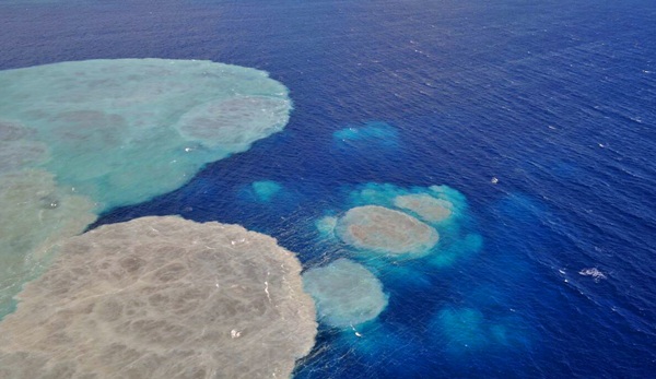
Appearance of the stain on the eruptive area Wednesday. | DA
DIARIODEAVISOS.COM | SANTA CRUZ DE TENERIFE
The National Geographic Institute (IGN) has confirmed the direction of the Civil Protection Plan for Volcanic Risk (PEVOLCA) during yesterday there were 21 earthquakes on the island of El Hierro, none of them felt by the population.
The largest recorded magnitude was 2.6 on the Richter scale, an event occurred at 11:22 hours southwest of El Pinar at a depth of 13 kilometers.
Most movements are located in El Golfo, aligned NNW / SSE in the sea at a depth between 10 and 25 kilometers. Outside of this area and also above the earthquake was located one west of El Pinar at 08:10 hours at a depth of 13 km and a magnitude 2.0 on the Richter scale.
In total, since the day July 17, 2011 11 824 events have been found.
Tremor
The amplitude of the tremor signal has remained constant and low throughout the day with some slight increases in amplitude. It also confirms that there is evidence of a second source of tremor.
Deformation
In the horizontal components not seen any clear trend other than the regional. Vertically all stations show a clear tendency to collapse and those of El Golfo appear to indicate stability.
Evolution of the stain
Throughout the day has been increasing in size the area colored green emission increased, covering the end of the afternoon, a large area of the west coast and northern part of the coast.
No comments:
Post a Comment
Note: Only a member of this blog may post a comment.